Day 5 Tweed Range Scenic Drive
We woke early this morning as we had a full day packed ahead.
Our first stop was the beach. To finally brave the waves thankfully under the warmth of the sun. The children spent a good time rolling about in the soft fine sand. What I love about this is that you can easily swipe off all the sand thereafter as it doesn’t stick onto you.
However the water was still too cold so we simply paddled about on shore.
After we checked out from our hotel (at 12nn to the angst of the reception as they failed to notify me that check out time was actually 11am!), we headed south through the string of beach towns dotting the Gold Coast. Surfers Paradise and Broadbeach catered to the more upclass and touristy while the southern towns became markedly laid back.
In order of arrival, after Broadbeach, we passed Mermaid Beach, Miami Beach, Burleigh Heads, Palm Beach and then into Coolangatta. There is a row of eateries called Beach House Plaza facing the coast and we settled for pancakes for lunch and boy did we gorge on pancakes and maple syrup. Yum Yum! Pancakes in Paradise indeed.
We finally left Gold Coast behind us close to 3pm. Our second item on the itinerary today is to head to the Border Ranges National Park and catch a glimpse of Mt Warning. A bit of geography here. The entire hinterlands of Gold Coast/Byron Bay used to be this one huge volcano which blew off its head a long time ago.


What is left behind is a fertile valley within the caldera, the rims of which can still be traced from existing mountain ranges and a mountain smacked in the middle of it called The Pinnacle or Mt Warning. I suppose this could have once been the main shaft through which molten lava spewed out from?
Anyway while I was pre-warned that this journey would take 4 hours, I thought that was an exaggeration based on the distance on Google Maps. Once again I was proven wrong. Roads heading up towards Border Ranges National Park are not paved but all gravel and windy. While a straight line distance measured 10km, we were pretty sure we travelled closer to 30km.
We left the coast hugging a river for the town of Murwillumbah (“Where the mountains meet the sky”) which would be the starting point for our 4-hour drive. From Murwillumbah, we left the river behind us and ascended towards the town of Uki. Up to this point, we still saw many farm pastures, cows and sheep.
After that, everything became a more or less guesswork on where we should head to. Based on Google Maps, I was supposed to hit Lilian Rock and turn right for the shorter route to Border Ranges National Park. However the sign posts were not clear and we couldn’t be sure exactly where Lilian Rock is.
We finally stumbled onto a road map of the Border Ranges National Park which at least gave us some assurance that we were heading in the right direction. However what was unsettling though was to find out that from time to time, there were temporary road closures. Based on the map, I couldn’t be sure if the route I wanted to take was open or closed!
Thankfully on the rather dilapidated roads, we met a range rover and decided to follow it. Turned out it was the park ranger and he led us straight to the entrance of Border Ranges National Park. Honestly if you asked me to lead you there again, I might get lost all over. The ranger was very friendly and shared with us the directions to The Pinnacle and showed us how to deposit our park entrance fees.
Okay this totally blew my mind off. Apparently you need to take an envelope from a really rundown looking shack, put A$7 inside for the car entrance fee, seal the envelope and deposit it inside a rusty looking postbox which looks like it hasn’t been touched in years. That was just creepy. Why couldn’t I have just passed the money to the ranger? Because he didn’t accept it.
Anyway we bid the ranger farewell and entered the park. It didn’t take us too long to reach the lookout point. By then it was already 5.30pm. We had to hike up a 200m pathway through the forest and then suddenly emerge onto a wooden platform perched precariously at the edge of the mountain.
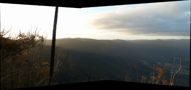
But the views was stunning! Even in the failing light, I was able to catch a panoramic view of the entire valley and trace the mountain ranges to form the caldera. This was one gigantic volcano when it was alive! We also saw Mt Warning in the middle of the valley dwarfed by the enormity of the landscape. While I wasn’t able to capture really good shots, the sunset views were also equally beautiful.
By the time we left the park, it was close to pitch black even though it was only 7pm. In the darkness, we spotted a wallaby hopping next to us and a white owl landed in the middle of the road in front of us.
Finally we got back to civilisation and passed several farm towns – Nimbin (“Where the Festival of Aquarius takes place”), Channon before arriving at Byron Bay close to 9pm.
The Bryon Bayside Motel is fully equipped with beds, sofa, kitchenette and even a washing machine. The downside though is that there are no elevators and there is a strict no noise policy after 10pm.